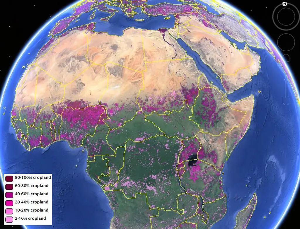
In a significant stride for global agricultural monitoring, researchers have unveiled an updated dataset detailing the worldwide distribution of agricultural lands as of 2015. This comprehensive dataset, which includes both croplands and pastures, was developed by a team led by Zahra Mehrabi from the Better Planet Laboratory at the University of Colorado. The research, published in the journal ‘Earth System Science Data’ (translated as ‘地球系统科学数据’ in Chinese), offers a crucial tool for understanding the evolving landscape of global agriculture and its far-reaching implications.
The dataset, which builds upon a previous study from the year 2000, provides a granular view of agricultural lands at a resolution of 5 arcminutes, roughly equivalent to 10 square kilometers at the Equator. This level of detail is vital for a wide range of applications, from modeling climate change impacts to assessing food security and biodiversity loss. “This dataset is a game-changer for anyone studying the intersection of agriculture and the environment,” Mehrabi explained. “It provides a comprehensive snapshot of global agricultural lands, enabling more accurate modeling and analysis.”
One of the standout features of this research is the development of a transparent and reproducible approach to updating the dataset. Previous efforts to create such datasets have been labor-intensive and infrequently repeated. By establishing a replicable methodology, the research team has paved the way for more regular updates and easier future reconstructions. “We wanted to make sure that this wasn’t just a one-off project,” Mehrabi noted. “By providing the code and data needed for reconstruction, we’re empowering other researchers to build on our work and keep the dataset current.”
The implications of this research extend beyond academia, particularly for the energy sector. Understanding the distribution of agricultural lands is crucial for planning renewable energy projects, such as bioenergy crops and solar farms, which often compete for land with food production. Accurate data can help stakeholders make informed decisions, balancing the need for energy production with food security and environmental conservation.
Moreover, the dataset can inform policies aimed at mitigating climate change. Agriculture is a significant contributor to greenhouse gas emissions, and understanding its global footprint is essential for developing effective mitigation strategies. By providing a detailed map of agricultural lands, this dataset can support efforts to reduce emissions and promote sustainable practices.
The research team has made the dataset freely available, along with the necessary code and data for reconstruction, ensuring that it can be readily accessed and utilized by the global community. This open-access approach underscores the importance of collaboration and transparency in addressing global challenges.
As the world grapples with the impacts of climate change and the growing demand for food and energy, datasets like this one become increasingly valuable. They provide the foundation for evidence-based decision-making, helping to shape policies and practices that can mitigate environmental degradation and promote sustainable development.
In the words of Mehrabi, “This dataset is a testament to the power of collaboration and innovation. By working together and leveraging new technologies, we can create tools that help us understand and address the complex challenges facing our planet.” As the research community continues to build on this work, the potential for impactful developments in the field of agriculture and environmental science is immense.