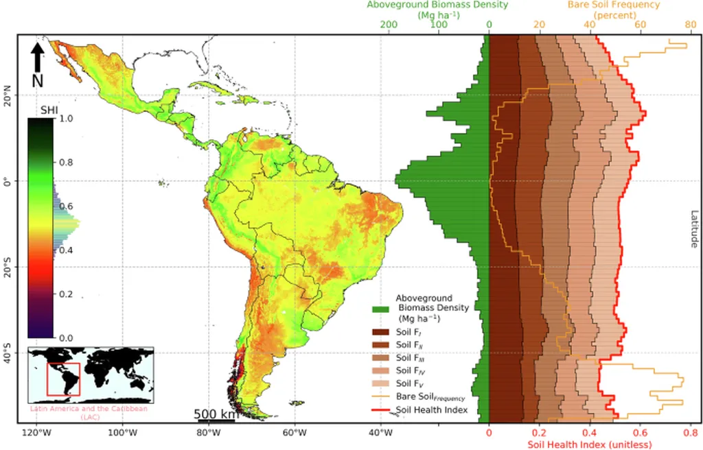
In the heart of the Caribbean, a researcher is making waves that could ripple across the global energy sector. Sunshine A. De Caires, from the Department of Food Production at The University of the West Indies, has published a comprehensive review in *Discover Soil* (translated as *Explore Soil*) that could revolutionize how we approach soil mapping and management. Her work, titled “Advancing soil mapping and management using geostatistics and integrated machine learning and remote sensing techniques: a synoptic review,” offers a fresh perspective on sustainable land management, precision agriculture, and environmental monitoring.
De Caires’ research delves into the evolution of classical and modern geostatistical methods, spanning from 2000 to 2024. She evaluates key techniques such as spatial autocorrelation, variogram analysis, kriging, and its variants, Bayesian models, Markov Chains, geostatistical simulations, and ensemble modeling. But what sets her work apart is her focus on hybrid approaches that fuse geostatistics with machine learning (ML) algorithms and remote sensing (RS) technologies.
“Hybrid approaches combining geostatistics with ML algorithms demonstrate promise in addressing spatial uncertainty,” De Caires explains. “RS data enhances covariate enrichment and near-real-time applications, which can be a game-changer for the energy sector.”
The energy sector, particularly renewable energy, relies heavily on understanding soil composition and health. Wind farms, solar parks, and bioenergy plantations all require detailed soil mapping to optimize land use and ensure sustainability. De Caires’ research suggests that integrating ML algorithms like Random Forest, Extreme Gradient Boosting, Support Vector Machines, and Artificial Neural Networks with traditional geostatistical methods can significantly improve prediction accuracy and sampling strategies.
However, the journey is not without its challenges. De Caires acknowledges that computational efficiency and uncertainty quantification remain hurdles. “Emerging trends such as Bayesian methods, multiscale modeling, and sensor networks show potential to mitigate these limitations,” she says, offering a glimpse into the future of soil mapping.
The implications for the energy sector are profound. More accurate soil mapping can lead to better site selection for renewable energy projects, improved land management practices, and enhanced environmental monitoring. This, in turn, can drive down costs, increase efficiency, and promote sustainability.
De Caires’ review is a valuable resource for researchers, practitioners, and policymakers engaged in data-driven land and soil management. It’s a call to action, urging the scientific community to focus on improving model accuracy, interpretability, transparency, and explainability. It’s a challenge to address data quality issues, scalability, and increasing sampling density to support robust spatial analysis and uncertainty quantification.
As we stand on the precipice of a renewable energy revolution, De Caires’ work serves as a reminder that the key to unlocking our energy future lies beneath our feet. It’s a testament to the power of interdisciplinary research and the potential of technology to transform our understanding of the world around us.
In the words of De Caires, “Future research should focus on improving model accuracy, interpretability, transparency, and explainability. Additionally, addressing data quality issues, scalability, and increasing sampling density to support robust spatial analysis and uncertainty quantification are major research gaps and future directions for soil mapping and information systems.”
Her work, published in *Discover Soil*, is a beacon of hope for a sustainable future, guiding us towards a world where technology and nature coexist in harmony.