In the heart of sub-Saharan Africa, fires burn with a ferocity and frequency that have long been underestimated, according to groundbreaking research published in the journal Geomatica (Geomatics). The study, led by Boris Ouattara of the Institute of Climate-Smart Agriculture at the Thuenen Institute in Germany, reveals that current satellite-based fire emission inventories are significantly undercounting the carbon emissions from fires in the region. This underestimation has profound implications for the energy sector, climate modeling, and policy development.
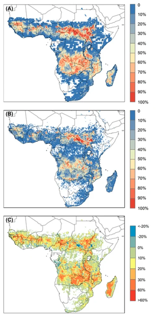
For years, scientists have relied on coarse-resolution satellite data to estimate fire emissions, but these tools have been blind to the smaller fires that are ubiquitous across sub-Saharan Africa. Enter the Visible Infrared Imaging Radiometer Suite (VIIRS), a satellite sensor with a resolution of 375 meters, which can detect even the smallest fires. By analyzing VIIRS data from 2013 to 2022, Ouattara and his team developed a high-resolution fire emission inventory that tells a starkly different story than previous estimates.
“The magnitude of emissions we’ve uncovered is staggering,” says Ouattara. “Our VIIRS-based inventory estimates average annual carbon emissions of 3.0 Pg C, which is 50–75% higher than most MODIS-based inventories.” MODIS, or Moderate Resolution Imaging Spectroradiometer, has been the go-to tool for fire monitoring, but its coarser resolution misses many small fires that contribute significantly to the overall emissions.
The study highlights that small fires, defined as those with a fire radiative power (FRP) of less than 10 MW, play a crucial role in the fire regime of sub-Saharan Africa. These fires are often ignited for agricultural purposes or to clear savanna landscapes and are particularly prevalent at the beginning and end of the fire season. By capturing these previously overlooked events, the VIIRS-based inventory provides a more accurate picture of the region’s fire activity and its impact on the global carbon cycle.
For the energy sector, these findings are a wake-up call. Accurate emissions data are essential for greenhouse gas accounting, atmospheric composition modeling, and the development of regional fire policies. “Underestimating emissions can lead to misguided policies and ineffective mitigation strategies,” Ouattara warns. “Our work underscores the importance of high-resolution detection and FRP-based modeling for capturing the full extent of African fire activity.”
The implications of this research extend beyond sub-Saharan Africa. As the world grapples with the challenges of climate change, accurate data on fire emissions will be crucial for informing global climate models and developing effective mitigation strategies. The VIIRS-based inventory developed by Ouattara and his team provides a valuable tool for researchers, policymakers, and industry stakeholders seeking to understand and address the impacts of biomass burning.
Looking ahead, this research could shape future developments in fire monitoring and emissions modeling. As satellite technology continues to advance, the resolution and accuracy of fire detection will only improve, paving the way for more precise emissions inventories. For the energy sector, this means better data for decision-making, more effective mitigation strategies, and ultimately, a clearer path toward a sustainable future.
In the words of Ouattara, “This is just the beginning. As we continue to refine our methods and incorporate new data, we’ll gain an even deeper understanding of the complex dynamics of fire in sub-Saharan Africa and its global implications.” With the publication of this study in Geomatica, the stage is set for a new era of fire monitoring and emissions accounting, one that promises to shed light on the hidden fires that have long been overlooked.