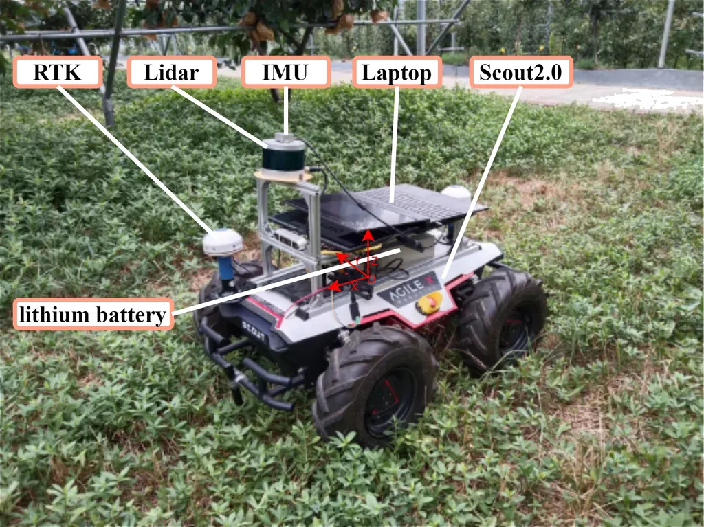
In the heart of South Korea, a groundbreaking study led by Seulgi Choi from the Interdisciplinary Program in Smart Agriculture at Kangwon National University is set to revolutionize autonomous navigation in orchards. The research, published in the journal *Agriculture* (which translates to “농업” in Korean), addresses critical challenges faced by the agricultural sector, including labor shortages and uneven terrain, by integrating Light Detection and Ranging (LiDAR) and Inertial Measurement Unit (IMU) data through Simultaneous Localization and Mapping (SLAM).
Choi’s innovative approach minimizes distortions in LiDAR scans caused by ground irregularities through real-time tilt correction based on IMU feedback. This enhancement not only improves localization accuracy but also ensures map stability, which is crucial for autonomous navigation in complex environments like orchards. “The integration of LiDAR and IMU data has significantly enhanced our system’s ability to navigate uneven terrain,” Choi explains. “This real-time tilt correction is a game-changer for precision agriculture.”
The study also introduces modifications to the Rapidly-Exploring Random Tree (RRT) algorithm, resulting in smoother and more efficient trajectories. The enhanced RRT generated paths that were 2.26 meters on average, compared to 2.59 meters with conventional RRT and 2.71 meters with the A* algorithm. Tracking performance saw a root mean square error of 0.890 meters and a maximum lateral deviation of 0.423 meters, with yaw stability improved by approximately 7% relative to the standard RRT.
These advancements are not just theoretical; they have been validated in real-world agricultural conditions. “Field results have shown the robustness and adaptability of our system,” Choi notes. “This technology has the potential to make autonomous navigation in orchards scalable and reliable.”
The implications for the agricultural sector are profound. With labor shortages becoming increasingly prevalent, autonomous navigation systems can help fill the gap, ensuring that crops are tended to efficiently and effectively. The enhanced path planning and stability offered by this research can lead to more precise and timely interventions, ultimately improving crop yields and quality.
Moreover, the integration of LiDAR and IMU data through SLAM opens up new possibilities for precision agriculture. Farmers can expect more accurate mapping and navigation, leading to better resource management and reduced operational costs. “This technology is not just about navigating orchards; it’s about optimizing every aspect of agricultural operations,” Choi adds.
As the agricultural sector continues to evolve, the need for innovative solutions to address labor shortages and terrain challenges will only grow. Choi’s research represents a significant step forward in this regard, offering a scalable and reliable approach to autonomous navigation. The findings highlight the potential of LiDAR–IMU sensor fusion and optimized path planning to transform precision agriculture, paving the way for a more efficient and sustainable future.
In the broader context, this research could also have implications for other sectors, including energy. Autonomous navigation systems enhanced by LiDAR and IMU data could be applied to inspecting and maintaining renewable energy infrastructure, such as solar farms and wind turbines, located in challenging terrains. The ability to navigate and map these environments accurately could lead to more efficient maintenance schedules and reduced downtime, ultimately improving the reliability and output of renewable energy sources.
As the world moves towards a more sustainable future, the integration of advanced technologies like those developed by Choi and her team will be crucial. The research published in *Agriculture* not only addresses immediate challenges in the agricultural sector but also lays the groundwork for broader applications that could benefit various industries. The future of autonomous navigation is here, and it’s looking more promising than ever.