In the delicate balance between agricultural productivity and environmental sustainability, a new study offers a promising tool for managing one of the most pressing challenges facing coastal regions: nitrate pollution. Morad Chahid, a researcher from the Laboratory of Applied and Marine Geosciences, Geotechnics and Geohazards (LR3G) at Abdelmalek Essaâdi University, has developed an explainable deep learning framework that could revolutionize how we monitor and manage groundwater quality under land use pressure.
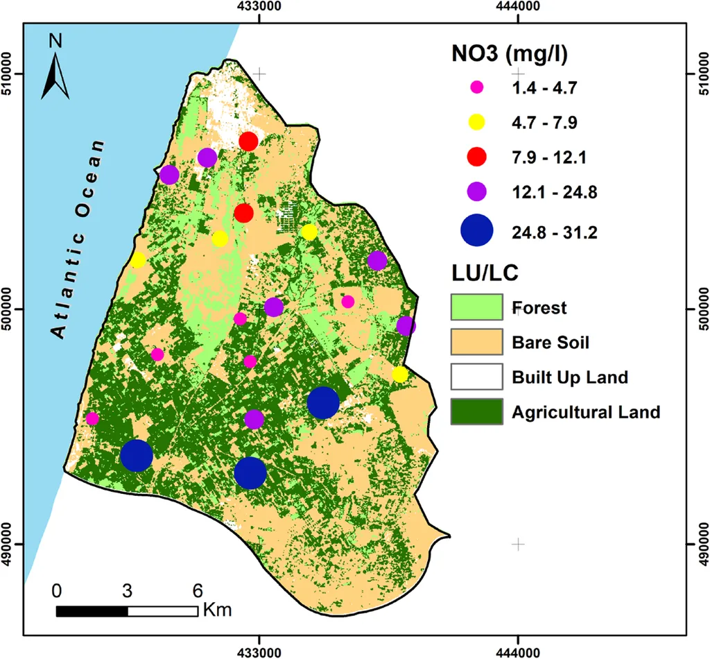
The study, published in *Scientific Reports* (translated to English as “Scientific Reports”), focuses on the critical issue of diffuse nitrate contamination, which threatens the quality of coastal groundwater resources. This is particularly relevant in areas experiencing agricultural intensification and rapid land use changes. Chahid’s framework integrates key hydrochemical parameters—such as electrical conductivity (EC), chloride (Cl−), organic matter (OM), and fecal coliforms (FC)—with remote-sensing derived indicators like the Normalized Difference Vegetation Index (NDVI) and land use/land cover (LU/LC).
“Our goal was to create a tool that not only predicts nitrate concentrations but also identifies areas at risk of elevated contamination,” Chahid explained. “By using explainable AI, we can provide transparent feature attribution, which is crucial for stakeholders to understand and act on the data.”
The research evaluated two deep learning models: a Multilayer Perceptron (MLP) and TabNet, a novel attention-based architecture designed for interpretable tabular data. TabNet outperformed MLP, achieving an overall accuracy of 81.60% and a Macro-averaged recall of 84.13%. This high level of accuracy is a significant step forward in the precision of environmental impact assessments.
LASSO regression identified fecal coliforms (FC) and electrical conductivity (EC) as dominant predictors, highlighting the combined influence of domestic wastewater and agricultural runoff on nitrate contamination. “This dual influence underscores the need for integrated management strategies that address both agricultural practices and urban wastewater treatment,” Chahid noted.
The output risk maps revealed spatially heterogeneous contamination patterns, with hotspots concentrated in agricultural and peri-urban areas. These maps provide a clear visual representation of where interventions are most needed, offering a strategic advantage for groundwater monitoring and management.
For the energy sector, the implications are substantial. Groundwater is a vital resource for various energy-related activities, including cooling processes in power plants and hydraulic fracturing. Ensuring the quality of this resource is crucial for sustainable operations. “By integrating explainable AI with geospatial analysis, we can guide targeted groundwater monitoring and management strategies,” Chahid said. “This approach is transferable to other vulnerable coastal aquifers, supporting sustainable groundwater governance under diffuse pollution conditions.”
The study’s findings highlight the importance of leveraging advanced technologies to address environmental challenges. As coastal regions continue to face land use pressures, tools like Chahid’s framework will be essential for balancing economic development with environmental stewardship. The research not only provides a practical solution for immediate concerns but also sets a precedent for future developments in the field.
In an era where data-driven decision-making is becoming increasingly important, Chahid’s work offers a blueprint for how AI can be used to tackle complex environmental issues. By making the data interpretable and actionable, this framework could shape the future of groundwater management, ensuring that this critical resource remains viable for generations to come.