In a groundbreaking advancement for precision agriculture and hydrological modeling, researchers have developed a novel algorithm that promises to revolutionize the way we monitor and utilize soil moisture data. Published in the esteemed journal *Geoderma* (which translates to *Soil Science*), this study introduces a spatiotemporal fusion algorithm based on Fourier transform (STFFT), which integrates machine learning and radiative transfer models to generate high-resolution soil moisture maps.
Led by Xuqian Bai of the Key Laboratory of Agricultural Soil and Water Engineering in Arid and Semiarid Areas at Northwest A&F University in China, the research addresses a critical challenge in remote sensing: the trade-off between spatial and temporal resolution. Traditional methods often struggle to provide detailed soil moisture data at a granular scale, limiting their utility in precision agriculture and climate research.
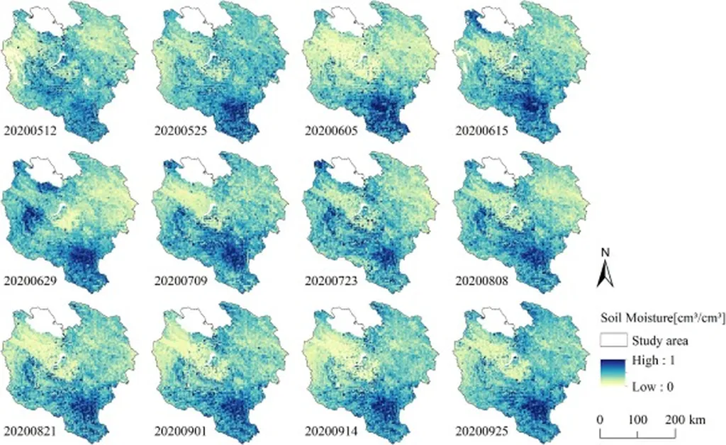
The STFFT algorithm, however, leverages the power of Sentinel-1 and Sentinel-2 datasets to downscale Soil Moisture Active and Passive (SMAP) products, producing daily surface soil moisture (SSM) maps with a remarkable 20-meter spatial resolution. This level of detail is unprecedented and offers significant advantages for various applications, including precision agriculture and hydrological modeling.
“STFFT is more adept at accommodating SSM data marked by significant heterogeneity and scale discrepancies compared to traditional spatiotemporal fusion algorithms,” Bai explained. This enhanced capability is crucial for accurately mapping soil moisture in diverse land cover types, which is essential for optimizing agricultural practices and managing water resources effectively.
The integration of Random Forest (RF) with the Water Cloud Model (WCM) and the radiative transfer model (PROSAIL) allows the algorithm to elucidate the intricate correlations between remote sensing variables and soil moisture. This comprehensive framework achieves an average correlation coefficient (R) of 0.892 and a root mean square error (RMSE) of 0.034 m³/m³, demonstrating markedly improved accuracy and robustness compared to benchmark methods.
The implications of this research are far-reaching, particularly for the energy sector. Accurate soil moisture data is vital for optimizing irrigation systems, which in turn can enhance energy efficiency in agricultural operations. By providing detailed and reliable soil moisture information, the STFFT algorithm can help farmers and energy providers make informed decisions, ultimately leading to more sustainable and efficient resource management.
As the world grapples with the challenges of climate change and water scarcity, innovations like the STFFT algorithm offer a beacon of hope. By bridging the gap between spatial and temporal resolution, this technology paves the way for more precise and effective agricultural and hydrological practices.
In the words of Bai, “This study introduces an improved methodology for producing fine-scale soil moisture products characterized by enhanced spatiotemporal continuity and reliability.” The future of soil moisture monitoring looks brighter than ever, thanks to the pioneering work of Bai and his team.