In the arid landscapes of North Wollo, Ethiopia, where rainfall is as unpredictable as it is crucial, a groundbreaking study offers a beacon of hope for agricultural sustainability. Daniel Desalegn, a researcher from the Department of Water Resources and Irrigation Engineering at Woldia University, has pioneered a geospatial approach to identify potential rainwater harvesting (RWH) sites, potentially transforming the region’s agricultural resilience.
The study, published in ‘Discover Applied Sciences’ (translated as ‘Discover Practical Sciences’), leverages Geographic Information Systems (GIS) and Multi-Criteria Decision Analysis (MCDA) to pinpoint ideal locations for RWH. “The irregular distribution of rainfall in North Wollo poses significant challenges to food security,” Desalegn explains. “By harnessing geospatial technology, we can strategically place RWH structures to maximize water collection and mitigate the impacts of drought.”
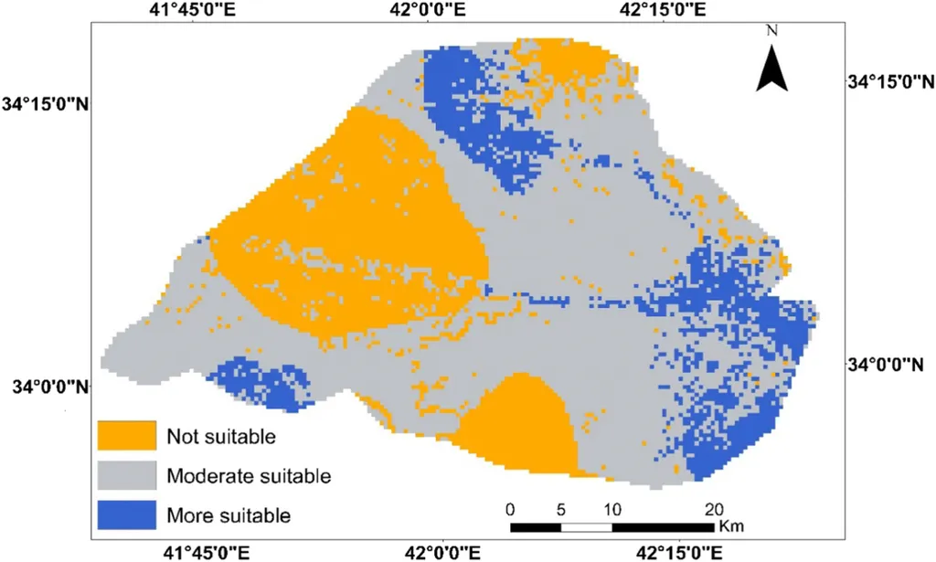
The research employs the Analytical Hierarchy Process (AHP) to evaluate five physical parameters, ensuring a consistent weighting of each component. A GIS-based Soil Conservation Service-Curve Number (SCS-CN) model then estimates the depth of runoff potential based on annual rainfall. The findings are promising: 57.3% of the Gurnd watershed is either suitable or highly suitable for RWH, covering 301.5 hectares of the total 525.3 hectares.
However, the study also reveals a stark reality: 65.2% of existing RWH structures are non-functional. “This discrepancy highlights the need for site-specific suitability assessments,” Desalegn notes. “Many structures may have been built without considering the unique physical parameters of the location, leading to inefficiencies and operational challenges.”
The implications for the energy sector are significant. As water scarcity intensifies, the demand for sustainable agricultural practices grows. RWH not only enhances food security but also reduces the energy-intensive processes associated with water extraction and transportation. By optimizing RWH site selection, the study paves the way for more efficient water management, potentially lowering costs and improving energy sustainability.
Desalegn’s research offers a blueprint for future developments in the field. “This methodology can be replicated in other regions facing similar challenges,” he says. “By integrating geospatial technology and MCDA, we can create tailored solutions that enhance agricultural resilience and sustainability.”
As the world grapples with the impacts of climate change, studies like Desalegn’s provide a roadmap for innovative, data-driven approaches to water management. The integration of GIS and MCDA not only optimizes RWH site selection but also sets a precedent for future research, offering hope for a more sustainable and resilient agricultural future.