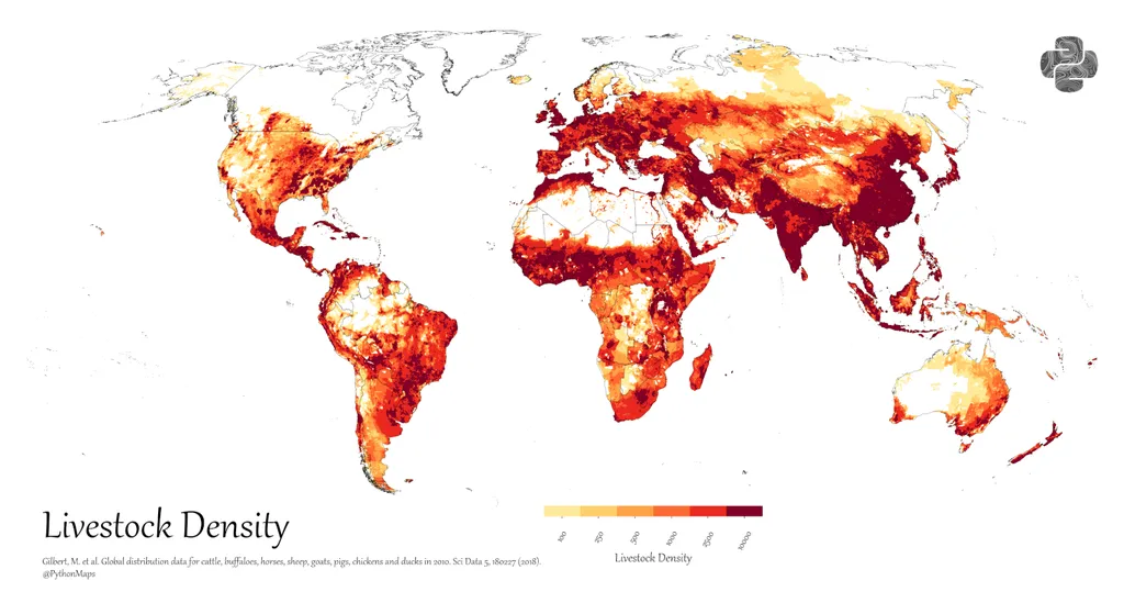
In a groundbreaking development for global agriculture and food security, researchers have unveiled the first annual gridded livestock maps of the world, spanning six decades from 1961 to 2021. This innovative dataset, dubbed AGLW (Annual Gridded Livestock of the World), was developed by a team led by Z. Du from the School of Information and Communication Engineering at Dalian University of Technology in China. The study, published in the journal *Earth System Science Data* (translated as “地球系统科学数据”), offers an unprecedented look at the spatio-temporal dynamics of global livestock populations, providing critical insights for policymakers, agricultural practitioners, and researchers alike.
The AGLW dataset was created by integrating the Food and Agriculture Organization’s (FAO) Corporate Statistical Database (FAOSTAT) with a Random Forest regression model, all implemented on Google Earth Engine (GEE). This integration allowed the team to produce high-resolution maps at a spatial resolution of 5 kilometers, offering a detailed and continuous view of livestock distributions over time. “By combining these advanced technologies, we were able to overcome the limitations of previous livestock mapping products, which often lacked spatio-temporal continuity and resolution,” explained Du.
The maps reveal significant trends and fluctuations in livestock populations across the globe. For instance, the data highlights a notable increase in pig stock in China and a decline in horse stock in Poland. These insights are invaluable for understanding the impacts of livestock dynamics on food security, public health, socio-economic development, and sustainable agriculture. “Our dataset serves as a crucial resource for enhancing our understanding of global livestock dynamics, informing policy decisions, and guiding sustainable agricultural practices,” Du added.
The AGLW maps were rigorously evaluated from three perspectives: model level, finer-scale statistic level, and pixel level, with correlation coefficients ranging from 0.65 to 0.88. This high level of accuracy ensures that the dataset is reliable and can be used with confidence for various applications. Additionally, the researchers have released per-pixel, per-year uncertainty layers, recommending that users consult these layers, especially for early decades and data-sparse regions.
The implications of this research are far-reaching. For the energy sector, understanding livestock dynamics is crucial for optimizing resource allocation and reducing environmental impacts. Livestock farming is a significant contributor to greenhouse gas emissions, and accurate data can help in developing strategies to mitigate these effects. Moreover, the dataset can inform policies aimed at promoting sustainable agricultural practices and enhancing resilience in both ecological and human systems.
As the world grapples with the challenges of climate change and food security, the AGLW dataset provides a valuable tool for researchers and policymakers. By offering a comprehensive and continuous view of global livestock populations, it paves the way for more informed decision-making and sustainable development. The full archive of AGLW is available at https://doi.org/10.5281/zenodo.17128483, making it accessible for further research and application.
In summary, the AGLW dataset represents a significant advancement in the field of agricultural science and technology. By providing detailed and accurate maps of global livestock distributions, it offers a wealth of information that can be used to address some of the most pressing challenges facing the world today. As Du and his team continue to refine and expand this dataset, it is likely to become an even more valuable resource for researchers, policymakers, and agricultural practitioners worldwide.