In the heart of southern India, the Thamirabarani River Basin is facing a silent crisis, one that could have profound implications for the region’s agricultural sector. A recent study published in *Discover Geoscience* has shed light on the complex interplay of climatic and anthropogenic factors that are driving land degradation in this vital basin. The research, led by S. Kaliraj from the National Centre for Earth Science Studies (NCESS), Ministry of Earth Sciences, Govt. of India, employs a sophisticated geospatial approach to assess the basin’s vulnerability to land degradation, offering crucial insights for policymakers and farmers alike.
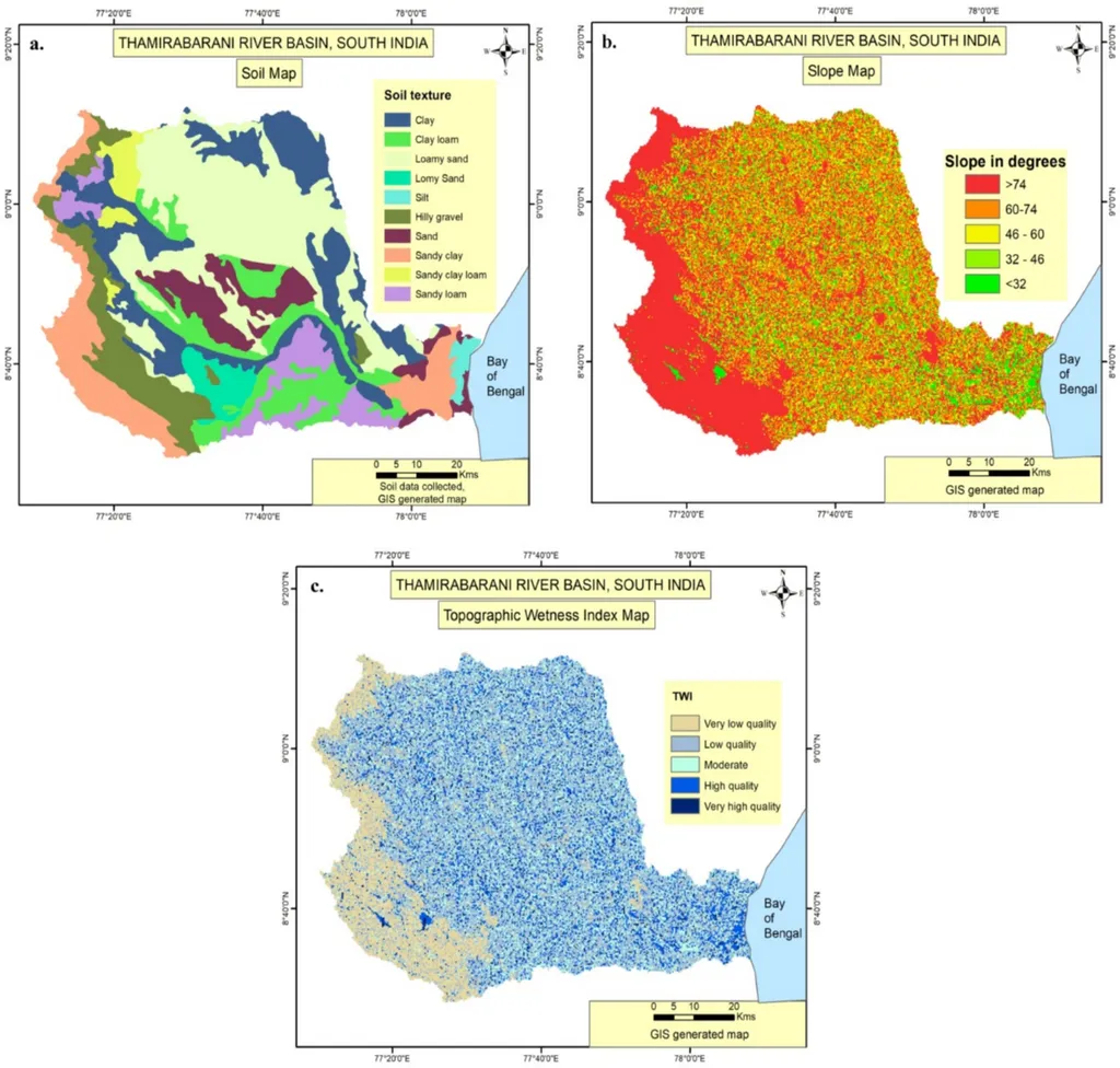
The study introduces the Land Degradation Vulnerability Index (LDVI), a comprehensive tool that integrates the Climatic Quality Index (CQI), Soil Quality Index (SQI), and Vegetative Quality Index (VQI). By analyzing multi-temporal datasets, including rainfall records, NDVI, slope, soil type, and topographic wetness, the researchers have painted a detailed picture of the basin’s environmental dynamics. The findings reveal a stark reality: approximately 35.3% of the basin is highly vulnerable to degradation, with 5.6% classified as very high and 29.7% as high. This vulnerability is exacerbated by rainfall variability, sparse vegetation, and arid conditions, which collectively undermine the region’s agricultural potential.
“Rainfall variability, sparse vegetation, and arid conditions further exacerbate worsen land conditions. Subsequent intense monsoonal rainfall generates high surface runoff, leading to sheet erosion, rill formation, and topsoil loss,” Kaliraj explained. This erosion not only degrades the land but also reduces its productivity, posing a significant threat to the livelihoods of local farmers.
The study’s multivariate statistical analyses identified slope and aridity as dominant drivers of vulnerability. Principal Component Analysis (PCA) confirmed this, with aridity and rainfall variability showing high loadings on PC2. Hierarchical Cluster Analysis (HCA) further delineated 25% of the basin as severely degraded, primarily due to anthropogenic pressures. These findings underscore the urgent need for integrated land and water resource management strategies.
For the agricultural sector, the implications are clear. Land degradation directly impacts crop yields and soil fertility, ultimately affecting farmers’ incomes and food security. The study’s emphasis on afforestation, soil conservation, and sustainable agriculture practices offers a roadmap for mitigating these impacts. By adopting these strategies, farmers can enhance soil health, improve water retention, and boost agricultural productivity.
The research also highlights the importance of spatial vulnerability assessments in guiding targeted interventions. By identifying the most vulnerable areas, policymakers can allocate resources more effectively, ensuring that conservation efforts are focused where they are needed most. This targeted approach can maximize the impact of land and water management strategies, ultimately safeguarding the region’s agricultural future.
As the world grapples with the challenges of climate change and land degradation, studies like this one provide invaluable insights into the complex dynamics at play. By understanding these dynamics, we can develop more resilient agricultural systems that can withstand the pressures of a changing climate. The research led by Kaliraj not only advances our scientific knowledge but also offers practical solutions for protecting the livelihoods of farmers in the Thamirabarani River Basin and beyond.
In the face of these challenges, the call to action is clear. Integrated land and water resource management, coupled with sustainable agricultural practices, is essential for mitigating ecosystem decline and ensuring the long-term viability of the region’s agricultural sector. As we look to the future, the insights gained from this study will be instrumental in shaping policies and practices that promote sustainable agriculture and food security.