In the rugged landscapes of Southern Ethiopia, where steep terrain meets heavy rainfall, landslides are a constant threat to communities and agriculture. A recent study published in *Advances in Civil Engineering* sheds light on the vulnerability of the Maze and Zenti catchments in the Gofa Zone, offering critical insights that could shape future disaster management and agricultural planning. Led by Ephrem Getahun of the Department of Geology, the research employs advanced Geographic Information System (GIS) techniques to assess landslide susceptibility and risk, providing a roadmap for mitigating the impacts of these natural hazards.
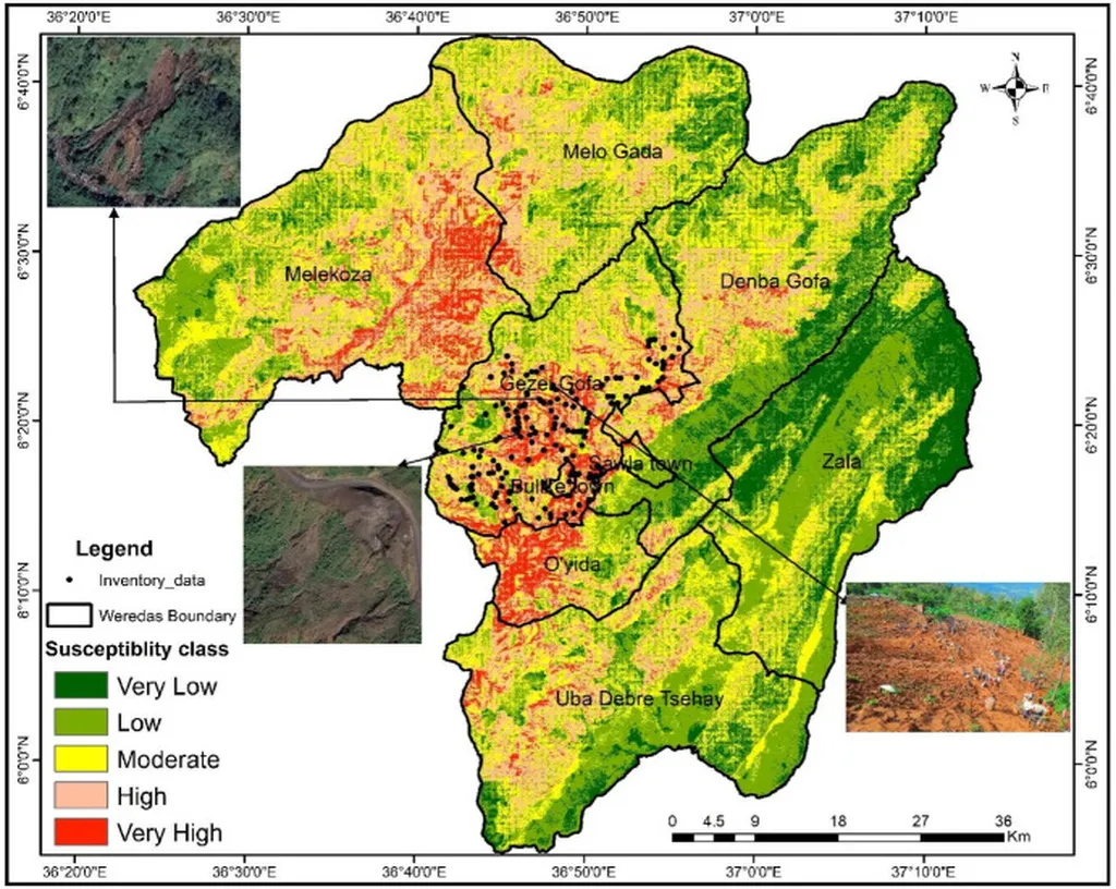
The study integrates 12 key factors, including slope, rainfall, land use, and soil type, to create detailed susceptibility maps. Using two models—the analytical hierarchy process (AHP) and the weight of evidence (WoE)—the researchers classified the region into five susceptibility zones, from very low to very high. The findings reveal that a significant portion of the area is at high risk. “The AHP model indicates that over 52% of the study area falls within moderate to very high susceptibility zones,” Getahun explains. “This is a stark reminder of the precarious balance between nature and human activity in these regions.”
The WoE model further refines the assessment, identifying quaternary sediments, clay-rich soils, and areas with high lineament density as particularly vulnerable. With a predictive accuracy of 84.3%, the WoE model outperforms the AHP model, offering a more reliable tool for disaster planning. “The superior accuracy of the WoE model is a game-changer,” Getahun notes. “It allows us to pinpoint high-risk areas with greater precision, enabling targeted interventions that can save lives and livelihoods.”
The implications for the agriculture sector are profound. The study reveals that 63% of agricultural lands in the region fall within high to very high susceptibility zones, posing a direct threat to food security and rural livelihoods. “Landslides don’t just destroy infrastructure; they disrupt the very foundation of rural economies,” Getahun says. “By identifying these high-risk areas, we can prioritize sustainable land-use planning and implement measures like terracing, bioengineering, and afforestation to stabilize slopes and protect farmlands.”
The research also highlights the urgent need for early warning systems and relocation planning for settlements like Tunga, Ula, Zulo, and Kencho Secha, which are located in very high susceptibility zones. “These communities are on the front lines of landslide risk,” Getahun emphasizes. “Immediate action is crucial to safeguard lives and ensure the resilience of these regions.”
As the world grapples with the impacts of climate change, the study underscores the importance of continuous monitoring and hybrid modeling approaches. By integrating climate change projections, future research can enhance landslide prediction and mitigation efforts, offering a more robust framework for disaster management. “This is just the beginning,” Getahun concludes. “The insights from this study will guide future developments in the field, ensuring that we are better prepared to face the challenges ahead.”
Published in *Advances in Civil Engineering* and led by Ephrem Getahun of the Department of Geology, this research not only advances our understanding of landslide susceptibility but also provides a critical tool for protecting communities and agricultural lands in vulnerable regions. As the world continues to confront the realities of climate change and environmental degradation, studies like this offer hope and a path forward.