In the heart of Northeast Thailand, where vast expanses of sugarcane sway under the tropical sun, a groundbreaking study is transforming the way farmers tackle one of agriculture’s most persistent foes: weeds. By harnessing the power of satellite data and machine learning, researchers have developed a method to detect and map weed infestations with unprecedented accuracy, offering a beacon of hope for sustainable and efficient crop management.
The study, led by Savittri Ratanopad Suwanlee from the Department of Geography at Mahasarakham University, combines data from the European Space Agency’s Sentinel-1 and Sentinel-2 satellites with a robust machine learning algorithm known as random forest. This fusion of technology and data science is revolutionizing precision agriculture, enabling farmers to identify and address weed problems before they escalate.
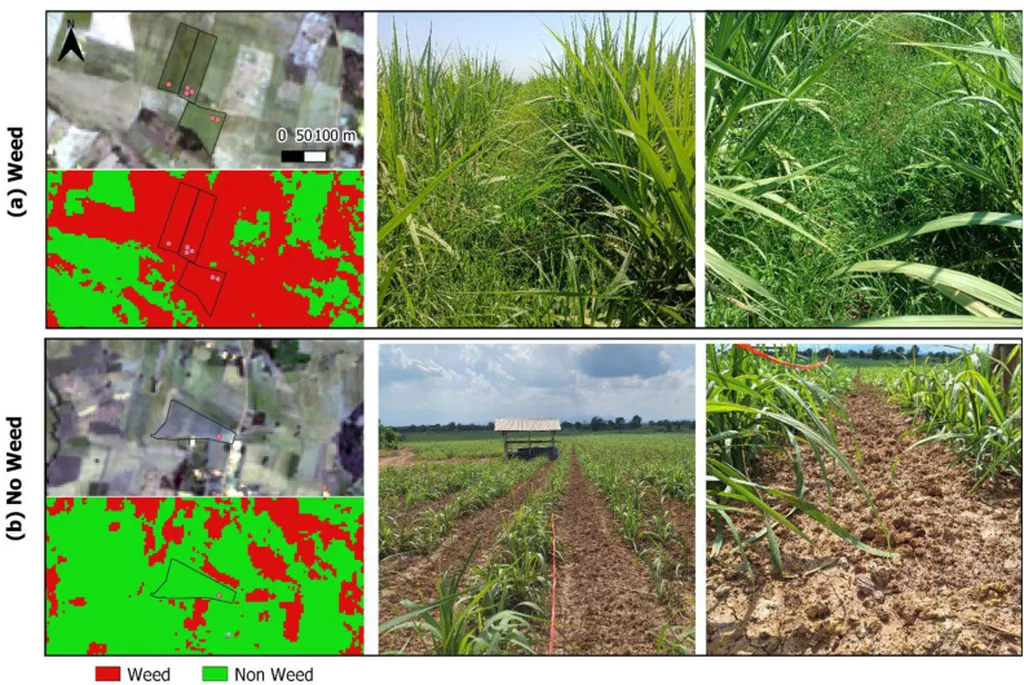
“Weed classification in sugarcane fields in Northeast Thailand from multi-temporal Sentinel-1 and Sentinel-2 data together with random forest algorithm,” published in *Science of Remote Sensing*, details how the integration of these advanced tools can significantly enhance the detection capabilities of weed infestations. The research team achieved an impressive 96% accuracy in classifying weed presence, with F1 scores exceeding 93%. This level of precision is a game-changer for the agriculture sector, where timely and accurate weed detection is crucial for sustainable crop production and management.
The study utilized a large dataset of 744 reference points to train and validate the weed identification model. The combination of Sentinel-1 and Sentinel-2 data proved to be particularly effective, addressing challenges posed by mixed pixels in small fields and providing deeper insights into field variability over large scales. “The combined S1 and S2 dataset significantly enhanced the detection capabilities of the best RF model,” Suwanlee explained, highlighting the synergy between different data sources.
For the agriculture sector, the implications are profound. Accurate and timely weed detection allows farmers to implement targeted weed management strategies, reducing the need for broad-spectrum herbicides and promoting more sustainable farming practices. This not only cuts costs but also minimizes the environmental impact, a critical consideration in an era of increasing climate change concerns.
The study’s findings also underscore the importance of multi-temporal data in agricultural monitoring. By analyzing data collected over time, researchers can identify high-density weed zones and track changes in weed infestations, enabling proactive and adaptive management strategies. This approach is particularly valuable in regions like Northeast Thailand, where sugarcane cultivation is a major economic driver.
Looking ahead, the research presents a scientifically robust and operationally scalable framework for monitoring weed infestations in sugarcane cultivation. The proposed approach demonstrates strong potential for advancing sustainable precision agriculture by facilitating timely and spatially precise interventions. As the agriculture sector continues to embrace technology, the integration of satellite data and machine learning is poised to play an increasingly vital role in ensuring food security and environmental sustainability.
In the words of Suwanlee, “Our work presents a scientifically robust and operationally scalable framework for monitoring weed infestations in sugarcane cultivation.” This innovative approach not only enhances the efficiency of weed management but also paves the way for a more sustainable and productive future for agriculture. As researchers and farmers continue to collaborate, the possibilities for leveraging technology to address agricultural challenges are limitless.