In the ever-evolving landscape of agritech, a new player has emerged to enhance global soil moisture mapping, offering promising implications for agriculture and water resource management. Researchers have developed an innovative algorithm that leverages data from the China–France Oceanography Satellite (CFOSAT), potentially revolutionizing how we monitor and manage soil moisture on a global scale.
The study, published in the IEEE Journal of Selected Topics in Applied Earth Observations and Remote Sensing, introduces the Adaptive Backscatter Change Tracking (ABCT) algorithm. This algorithm is designed to retrieve absolute soil moisture data from CFOSAT’s scatterometer measurements, providing a novel approach to soil moisture mapping. “The ABCT algorithm assumes a stable roughness, where changes in backscattering are primarily attributed to soil moisture variation based on a logarithmic relationship,” explains lead author Pan Duan from the National Key Laboratory of Water Disaster Prevention at Hohai University in Nanjing, China.
The ABCT algorithm incorporates a vegetation influence coefficient, which adaptively scales with changes in the Normalized Difference Vegetation Index. This feature allows the algorithm to isolate changes in the backscatter signal due to soil moisture while minimizing false readings from vegetation growth or wilting. “This adaptive approach ensures that the algorithm accurately captures soil moisture variations, even in areas with significant vegetation changes,” Duan adds.
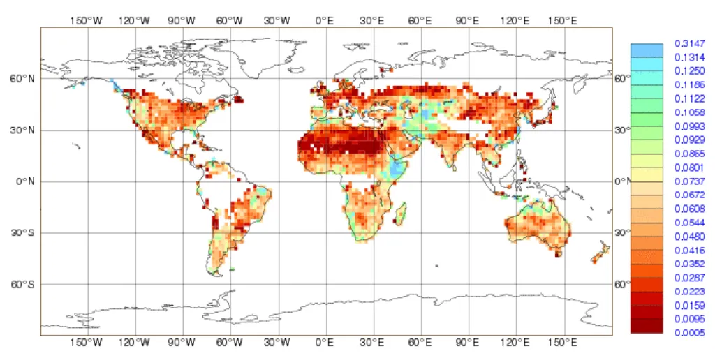
The performance of the CFOSAT ABCT algorithm was rigorously evaluated against extensive in-situ soil moisture data. The results were impressive, with the Vertical-Vertical Polarization Ascending Orbit (VV Asc) showing the highest accuracy, indicated by a Pearson’s correlation coefficient of 0.68 and an unbiased root mean squared error (ubRMSE) of 0.057 m³/m³. Comparative analysis with the Advanced Scatterometer (ASCAT) data revealed that while the ABCT algorithm’s correlation was slightly lower than that of the official EUMETSAT H SAF product, it notably improved the bias and ubRMSE metrics.
For the agriculture sector, this research holds significant commercial potential. Accurate soil moisture mapping is crucial for optimizing irrigation, improving crop yields, and managing water resources efficiently. The ABCT algorithm’s ability to provide reliable soil moisture data can empower farmers and agronomists with the tools they need to make informed decisions, ultimately enhancing agricultural productivity and sustainability.
Moreover, the integration of CFOSAT data into global soil moisture mapping complements existing satellite missions and sensors, such as SMAP, SMOS, ASCAT, AMSR2, and FY-3/MWRI. This synergy can lead to more comprehensive and accurate soil moisture monitoring, benefiting various applications, from precision agriculture to climate modeling.
As we look to the future, the ABCT algorithm and CFOSAT’s capabilities open new avenues for research and development in the field of remote sensing. The study underscores the importance of leveraging advanced technologies to address critical challenges in agriculture and water resource management. With continued innovation and collaboration, we can expect further advancements that will shape the future of global soil moisture mapping and its impact on the agriculture sector.